The CRUST
V. B. Piip
Moscow State University, Russia,
piipvalentina@hotmail.com
Introduction |
Method of interpretation |
Designations
Kuril Trench |
Kuril Basin |
Sakhalin and Tatar Strait
Horizontal velocity map-slice |
Cross-section of the Earth Crust along Geotraverse
Introduction
Structure of the Crust at the region of the geotraverse was
received from reinterpretation of data of 11 Deep Seismic
Sounding profiles
that are disposed at the area of geotraverse and neighboring areas.
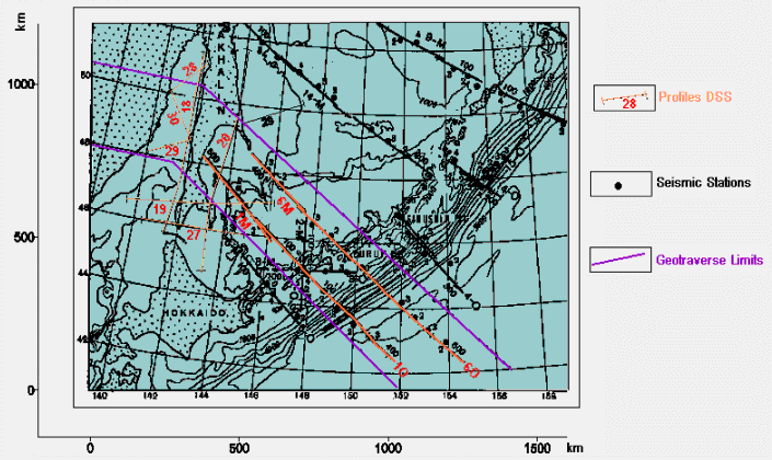
Seven from the profiles - 18, 19, 20, 27, 28, 29 and 30
- are located near
shores of Sakhalin. Institute of Earth Physics and Sakhalin Integrated
Institute carried out the seismic works along these profiles in 1963 - 1964
years. Four profile - 1M, 1O, 6M and 6O - are disposed
in region of Kuril
Trench and Kuril Basin. The seismic measurements along them were made in
the period of International Geophysical Year in 1958 - 1959 by Institute of
Physics of Earth of Academy of Sciences of USSR. The seismic works were
made at most high level for that time. Over 20 profiles were investigated
in that period.
Fig.1 Map of location of deep
seismic sounding profiles at the geotraverse region
Interpretation of the data fulfilled in that time had served by basis for studying of geological structure
of the region
( Structure ..., 1964 ).
Travel time curves of first arrivals along the profiles were published in
Structure ..., 1964
Deep ..., 1971 .
Now they have been digitized and reinterpreted using new 2-D computer
technique . Length of the lines varies from 250 to 750 km. Detailed cross-
sections have been obtained down to 30 - 60 km depth. The new seismic cross-
sections correspond to old ones in depth of major boundaries and velocity
values in average only. Blocks of subducted oceanic plate and relic
subduction zone are distinguished in the seismic cross-sections and in
the velocity maps of the region.
Method of interpretation
The method of homogeneous functions was used for reinterpretation.
This 2-D interpretation method and computer program "Godograf"
were worked out in Moscow State University
( Piip, 1984 ;
Piip, 1991 ).
Method is based on local approximation of real velocity fields by
homogeneous functions of two coordinates. It allows receiving automatically
2-D inhomogeneous velocity fields defined in the nets of rectangle
grid of maximal size 250x 100 in cross-sections. Cross-sections are drawn
as field of velocity contours with constant interval (usually 0.1 - 0.2 km/s).
Seismic boundaries and faults are seen in those cross-sections. Interpreter
distinguishes them. Such representation of cross-sections allows easy
constructing of horizontal velocity depth maps - slices if several seismic
profiles were interpreted in the area. It is no need any initial model for
this interpretation technique therefore the received cross-sections are
maximal objective. Ray tracing method had verified reliability of them.
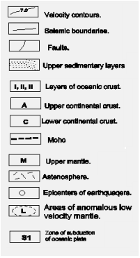
Designations
|
For continental crust: |
For oceanic crust: |
A is first layer of upper crust,
granite layer (V= 6.0 - 6.5 km/s).
B is second layer of upper crust
(V= 6.5 -7.0 km/s).
C is lower crust (V= 7.0 -8.0 km/s). |
I, II and III are first, second and third layers.
M is upper mantle.
L are zones of anomalous mantle.
Thin lines are velocity contours received automatically.
Bold lines (or dash lines) design the faults and seismic
boundaries. |
Kuril Trench
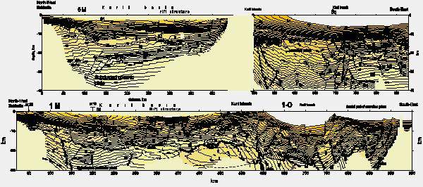
Two parallel profiles 6O and 1O cross the Kuril
Trench. The seismic cross-sections along them are shown here.
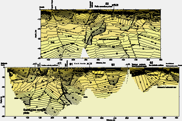
Fig.2 Seismic cross-
sections along two parallel profiles 1M - 1O (below) and
6M - 6O (above).
The same structures we can see in the cross-sections.
System of observation is more detailed for profile 1M - 1O. S1 indicates
a location of subduction zone. Contour interval is 0.2 km/s. Vertical
exaggeration is 4:1

More detailed view of seismic cross-section
Main structures of subduction zone are distinguished in the cross-
sections. These are accretion prism, subducting third layer of oceanic
slab, hanging wing of subduction zone. Also complex structure of frontal
part of accretion prism is seen in the cross-section of these profiles.
Deep cross-section of upper mantle is present in east part of cross-section
of profile 6O . Under influence of compression the oceanic slab
are divided on the layers III, M and M1 that are deformed
differently. It is necessary to note that system of observation for west
part of profile 6O is insufficient to discovery structure of
hanging wing of subduction zone. Depth of Moho is changed from 15 km to
30 km here.
There is very thick accretion prism (about 200 x 20 km) in the cross-
section of profile 1O . Detail structure of frontal part of
accretion prism can be seen in east part of profile. Deformed layers of
sediments and oceanic crust have been recover here by horizontal thrusts.
In whole numerous faults and thrust break the subducting slab in the
Kuril Trench. Complex and deformed blocks of oceanic crust and upper mantle
form hanging wing of subduction zone. Thickness of accretion prism sharply
changes in accordance to location of known transform faults of Pacific
oceanic plate.
Kuril Basin
Two parallel profiles 1M and 6M in fig.
1
cross the Kuril Basin at distance about 200 km one from another. Cross-
sections along these profiles are shown in fig. 2.
Depth of Moho is about 15 - 20 km here and it allows considering the crust
oceanic. Crust divided here in three layers I, II and III .
Two main structures are distinguished in the both cross-sections.
In western part of the profiles the blocks of subducted plate are traced.
They belong to a subduction zone, designed as S1 in
fig. 2 , 3 ,
4 , and 5 . It is disposed
near North - West edge of the Kuril Basin. In this zone oceanic crust of
the Kuril Basin was subducted beneath the continental crust of the Sakhalin
( Piip, 1997 ).
The profile 1M crosses profile 19 in the point where
block of oceanic slab S1 is disposes. The subduction zone is
present at the both cross-sections (fig. 2 and
3 ) that have a mis-tie among themselves well.
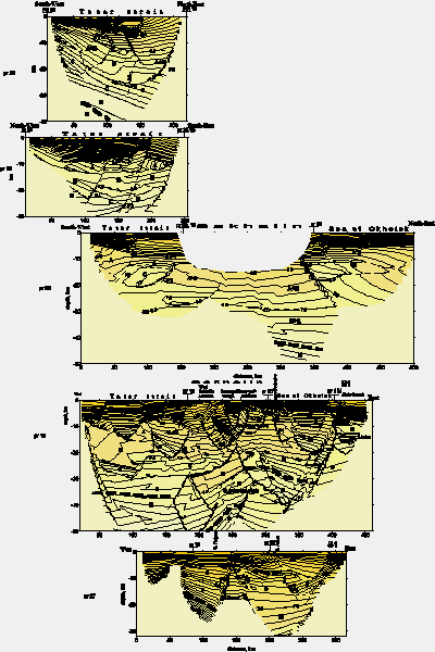
Fig.3 Seismic cross-
sections and geological interpretation along profiles from north to south
28, 30, 29, 19 and 27 crossing Sakhalin in sublatitude direction.
Main feature of cross-sections 19 and 27 is existing of structure of
subduction zone in the eastern part of the sections. Profile 19 have most
detailed system of observation. F1, f2, F3, F4 are designed faults in the
Tatar strait. Contour interval is 0.2 km/s, vertical exaggeration is 4:1
Full section of this subducted slab is seen in the cross-section of
profile 19 . The main feature of seismic cross-section for latitude
profile 19 which crosses exposures of ophiolitic rocks
of South Sakhalin is the presence of deep cross-section of subduction zone.
Lower oceanic crust and mantle dip 20o westward
from depth of 10 km (Kuril Basin) down to depth of 20 km in the central part
of profile forming a sequence of covers. Here oceanic slab is sloping and
in the upper part of the cross-section the subducted block of oceanic slab
is distinguished. At the depth of 30 - 50 km oceanic plate dips about 20
o again. In the west part of the profile 19 ,
layered continental crust and mantle are present. Thick of the crust is
about 35 km here.
This architecture of cross-section for profile 19 is confirmed
by cross-section for longitudinal profile 20 that crosses profile
19 and has a mis - tie at survey line intersections well.
Fig.4 Seismic section and
geological interpretation along profiles 18 (above) and 20 (below) located
near west and east shores of Sakhalin. Main components of
the sections are blocks of subducted oceanic plate distinguishing by high
velocity and high gradient values. Contours interval is 0.2 km/s, vertical
exaggeration is 4:1

More detailed view of seismic section
Profile 20 crosses of the subduction zone in a direction of
strike of the zone. The blocks of oceanic slab located in the southern
part of cross-section contains thrusts and blocks of oceanic crust and
mantle. One oceanic mantle thrust in the central part of the cross-section
rises up to depth of 10 km and it possibly served source of ophiolite at
the surface. Accretion prism can be seen at the 290 - 330 km of the profile.
It is noticeable that oceanic plate shows up sharply by high velocity
(up to 10 km/s) and high velocity gradient values in the seismic cross-
section. It seemed that these blocks were intruded or embedded in the
continental lithosphere that was disturbed by numerous faults here.
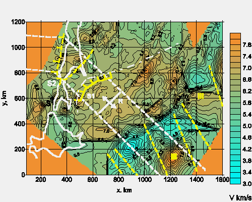
Fig.5
Velocity map-slice at the depth 12 km with elements of tectonic scheme.
The map describes structures of upper crust mainly. S1, S2 indicate
a location of subduction zones. The zones are designed by bold yellow lines
with dashes indicated a direction of dip. R is rift structure in
Kuril Basin. The third layer of Pacific oceanic plate is marked by digit
III. Known transform faults of Pacific plate are shown by yellow
dash lines. The white dash lines limit the area of the geotraverse.
Dot-and-dash line marks the northern border of Kuril Basin
More detailed view of map
Location of this subduction zone in the plane confidently is traced
on data of five profiles - 19, 20, 27, 1M and 6M and
coincides everywhere with wedge of Kuril Basin. This we can see in
fig. 5, where velocity map - slice at the depth
of 12 km is shown. Existing of zone subduction in back - ark basins is
supposed in plate tectonics.
In central part of profiles 1M and 6M in the Kuril
Basin the rift or the spreading structure is present. This structure sharply
is expressed in upper sedimentary layers. Faults forming it penetrate into
upper mantle, where zones with anomaly low (7.0 - 7.5 km/s) velocity,
possibly zones of smelting of matter of upper mantle are present.
Geologists propose existing of rift structure in Kuril Basin.
Maruyama et al., 1997
consider that at Miocene (25 Ma) the activity of sub - Asia superplume
peaked, accelerating the rifting in several major basins in East Asia,
in particular in the Kuril Basin. At the late Miocene the back - arc basin
reached its full extent.
Sakhalin and Tatar Strait
Structure of crust of Sakhalin and Tatar Strait is produced from the
cross-sections of profiles 18 and 20 passing along west
and east shores of Sakhalin and from profiles 28,29,30 crossing
Tatar Strait ( fig. 3 and 4 ).
The crust in this region is continental.
Its thickness is 30 - 40 km here.
Remnants of relic subduction zone are seen in the north part of
the seismic cross-section of profile 20 . Here anomalous crust is
observed. Relic subducted oceanic slab dips to south at 15 degrees here.
Accretion prism may be seen also. This relic subduction zone is designed
as S2 in fig. 3 , 4
and 5. One of the remnants of
oceanic plate S2 is present in the cross-section of profile
18 ( fig. 4 ). Sharp restricted domain
with high values of velocity and velocity gradient - vertical cross-
section of remnant of oceanic slab - is seen in the central part of the
cross-section. In upper layer of cross crust at the northern half of the
profile anywhere the remnants of third layer of oceanic plate are observed
although in the whole the lithosphere has continental type here. Crust
thickness is about 40 km.
Four seismic cross-sections of the profiles crossing the Tatar Strait
have similar feathers ( fig. 3 and
4 ). Everywhere the lower crust dips toward Sikhote Alin forming
steep steps. In western parts of the profiles the lower crust begins to
rises. Such structure of lower crust give possibility to define a direction
of relic subduction S2 that was taken place under Sikhote Alin
shores. The depth of basement is about 10 km in the Tatar strait.
Possible location and construction of relic subduction zone S2
in horizontal plane are seen at the velocity map - slice drawn for depth
of 12 km.
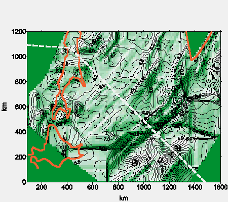
Fig.6
Velocity map-slice with shaded relief at the depth 12 km, showing
location of faults, relic zones of subduction and structures of crust
of Kuril trench and Sea of Okhotsk.
More detailed view of map
Horizontal velocity map - slice
Horizontal velocity map - slice at 12 km depth was constructed.
Data from 25 refraction profiles in the region were used in construction
of this map ( fig. 5 ).
As velocity contours are parallel to seismic boundaries as rule in
used cross-sections and velocity values increase with depth, the
horizontal velocity map - slice reflected location of depth structures
of crust. Areas with low velocity are troughs and areas with high
velocity are uplifts. Faults and thrust also are reflected in velocity
map - slices.
In ( fig. 5 ) the velocity map - slice with
elements of tectonic scheme is represented. The structures of upper crust
of the region are expressed in it. These are accretion prism, structure of
third layer of oceanic slab in region of Kuril trench, location relic
subduction zones and rift zone in the Kuril Basin. Several transform faults
of Pacific oceanic plate are shown in the map. Location of these faults are
known from seismological and magnetic data. We can see that active
subducting plate in region Kuril Trench is broken onto large segments that
turn around clockwise relatively of axe of the trench. This testifies
( Khain & Lomize, 1995 ).
that the subduction in this region is oblique.
Maruyama et al., 1997
also indicates on oblique direction of subduction in this region.
They propose that near Hokkaido shore a fore - arc sliver was formed in
the Kuril Arc by oblique subduction of Pacific Plate.
In ( fig. 6 ) the map - slice constructed
with shaded relief is shown. In this map we can see the main faults of
Kuril - Kamchatka region because the faults sharply are expressed in
velocity field.
Cross-section of the Earth Crust along
Geotraverse
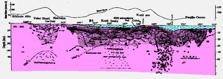
Fig.7 Resulting geological-
geophysical cross-section of the Earth crust along the geotraverse
More detailed view of cross-section
From the East to West we can trace following structure in the
geotraverse. In region of Kuril Trench thick accretion prism is present.
It sizes reaches 200x20 km2. Subducting third layer of
oceanic plate is broken by numerous faults and its blocks relaxed from
15 km to 30 km. Moho is disposed from 20 to 30 km here. Hang wing of
subduction zone in its frontal part forms a several normal faults and in
back part of it there are a series of reverse faults. Depth of Moho is
25 km here. At the 149o of longitude a sub - vertical fault
exists that divided the hang wing of subduction zone from the oceanic
crust of Kuril Basin. Moho is founded at the depth of 15 - 20 km here and
the crust is divided into three layers. In east part of Kuril Basin a
mantle plume is present. Anomalous low velocity mantle (v = 7 - 7.5 km/s)
reaches 300 km here. Possibly there are partially melting rocks here that
served by source of lava for volcanoes of Kuril Island Arc. Above this
anomalous mantle in the crust a rift zone exists. Faults are forming its
penetration from sedimentary layers to upper mantle. The rift zone is
disposed in centre of large lifted block of crust that is founded
above mantle plum. At west edge of Kuril basin the zone subduction
is present in that oceanic crust of Kuril Basin was embedded under
continental crust of Sakhalin Island. In Tatar strait the lower crust
forms steep steps relaxing toward Sikhote Alin shores. Possibly a
subduction zone existed here in past geological time. Basement is
disposed in the region of the geotraverse at the depth about 10 km
in average.
URL:
http://www.wdcb.ru/sep/traverses/Okhotsk_Geotraverse/crust.html
2001-2016 © WDC for SEP,
GC RAS
webmaster
|


