
FINE STRUCTURE OF JAPAN SUBDUCTION ZONE SEISMICITY
V. VADKOVSKY
Moscow State University, Russia, vad@dynamo.geol.msu.ru
Abstract |
Short description of studied area |
Methods of the studies |
Data sourses
What's the "nail"? |
How the "nail" grows |
Why the "nail" forms?
Conclusion |
Bibliography
Abstract
The study of the seismofocal zone structure conducted in the Japan
Islands' area. Spatial distribution of the earthquake hypocentres in the
depth range 0-120 km considered according to the data of the most entire
and reliable Japan Meteorological Agency (JMA) catalogue for the period of
1983-1990. In the hanging wedge of the crust and mantle, where strong
anisotropy of P- and S-waves velocities were established by many scientists,
the existence of almost vertical, isometrical in Earth surface projection,
short-life buildups of the earthquake hypocentres has been found. Such
buildups I named seismic "nails" .
The "nail" length comes from 15 to 30 km in depth. The upper part
of a "nail" either comes out to the Earth surface or not. The depth of the
"nail" middle can reach up to 100 km. A preferable direction (upwards or
downwards) of a "nail" forming in time is absent. Earthquake hypocentres
fill the "nail" body with equal probabilities on any depth in the process
of its forming.
The direct correlation of "nails" with strong earthquakes with
magnitudes Mb (JMA) >5.0 and with recent active volcanoes
doesn't exist. "Nails" compact, their almost vertical position in the range
of depth from 0 to 100 km and their short-time forming is led to the
conclusion of possible significance of fluids in this process. Processes
of serpentinite dehydratation and releasing of free water during partial
melting of wet amphibolite in the upper part of subduction zone are fluid
contributors. The existence of "nails" testifies the strong anisotropy of
the crust and upper mantle above the subducting plate.
Short description of studied area
The interaction of the Pacific and Eurasian plates is the main
process testifying the tectonic environment in the Japan Islands' area
beginning from the Jurassic
( Read and Watson, 1978 ),
( Khain and Lomize, 1995 ).
The existence of the double metamorphical belts parallel to the axes
of oceanic trenches, the curvature of the Japan arc in the
after-Cretaceous, identified by paleomagnetic data, differences of
basalt composition - from alkali to tholeitic
( Ringwood, 1975 ),
( Brimhall and Crerar, 1987 ),
presence of tension stresses in the backarc in deep basins of
the Japan Sea with spreading centres testifies diversity of the
phenomena, accompanied the interaction.
The main formations of metamorphism, playing the leading role in
the transformations of the subducted plates matter, have been defined
( Geological ..., 1984 ).
Strong (up to 6%) anisotropy of P- and S-waves velocities was established
in the crust and mantle beneath Japan Islands by the seismic tomography
method
( Hasegawa et al., 1991 ),
( Hasegawa et al., 1978 ),
( Okada et al., 1995 ).
Distribution of earthquake epicentres,
lines of the magnetic anomaly axes,
transform faults and recent active
volcanoes on the studying area

Methods of the studies
For the studies of the fine structure of seismicity it was developed
original computer program, permitting to represent on plate spatial
distribution of the hypocentres in the due area, the due time-window, and
the due depth interval. The uniqueness of the program is the fact that the
matrix of the group of transformations (rotations+changes of scale) are
implemented to coordinates of hypocentres each time when point of view is
changed, but not to the advance calculated screen coordinates of the
hypocentres, that can cause an undesirable discretisation of the screen
image.
The time characteristics of the forming of the "nails" were
studied with the help of Markov chains technique. The transitional
probabilities matrix M(i,j) to find the earthquake at the H(i)
depth after the earthquake, occurred at the H(j) depth, were
analysed. The Markov property of the matrix was defined.
Data sources
In this work there were used next datasets : the Japanese
earthquake catalogue - JMA (Japan Meteorological Agency)
( Global ..., 1994 ) ;
the global earthquake catalogue - PDE NEIC (National Earthquake
Information Center), USGS
( Global ..., 1994 ) ;
topography (5'x 5'); data on the recent active volcanoes
( CDIAC's ..., ) ;
data on the magnetic lineations and fracture zones of the World Ocean
( Magnetic ..., 1989 ).
All these data were obtained in the World Data Center for Solid Earth
Physics, Moscow. Special author's gratitude to the staff of the Center.
Beginning from 1983 seismological survey JMA carries out the
determination of earthquake hypocentre coordinates on the base of no
less than 5 registrated arrival times of P and S waves on more than 3
stations from the revised regional travel time tables
( The Seismological ..., 1994 ) .
The accuracy of earthquake
latitude and longitude determination is of 0.001 degrees, depth - 1 km for
shallow earthquakes and 4 - 5 km for more deep earthquakes. The change of
quality of determination of earthquake hypocentre parameters in JMA
catalogue was defined by the use of program described above.
The 3-D distribution of hypocentres in region
29oN-39oN and 128oE-138oE in depth interval
from 0 to 90 km during the year of 1981 and the similar distribution
for the same region in 1983

At the lower right parts of both figures the hystograms of
distributions of the number of earthquakes N in relation to depth H are
given. According to data for the year of 1981 the distribution has discrete
character whereas continuous distribution is observed for the 1983 data.
Hereafter the data of JMA catalogue beginning with 1983 were used
in this study. The seismofocal zone on area 30oN-40oN and
134oE-144oE from data
of 1990 is shown below in two projections: along oceanic trench (a) and
across it (b).

The inclination of seismofocal zone under the island arc and the
irregularity of earthquake distribution are clearly visible. The almost
vertical buildup of hypocentres have engaged our attention. Hereafter
we will define some characteristics of such buildups, named seismic
"nails"
( Vadkovsky, 1996 ) .
What's the "nail"?
When researching the JMA earthquake catalogue it was found that
buildups of earthquake hypocentres named "nails" form in a very short time
in the range from a few days to a month.
Example of such "nail" formed from 254 weak earthquakes for some days in
January-February of 1989 in the centre of Hokkaido island (with coordinates
43 o N, 142 o E) is shown below in two projections
(along the axis of trench and across it), allowing to judge of its almost
vertical position.
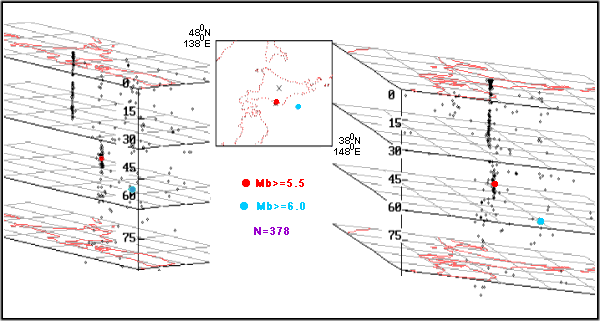
Epicentral picture of "nail" corresponds to the well-known seismic
phenomenon "swarm". The "nail" extends in depth to 30 km. The only strong
earthquake with magnitude Mb= 5.5 during this time period occurred very far
from this "nail". That is seen from epicentral picture at the right part of
figure.
Two "nails" formed during January of 1983 near of south coast of
Honshu island are shown in two projections below.
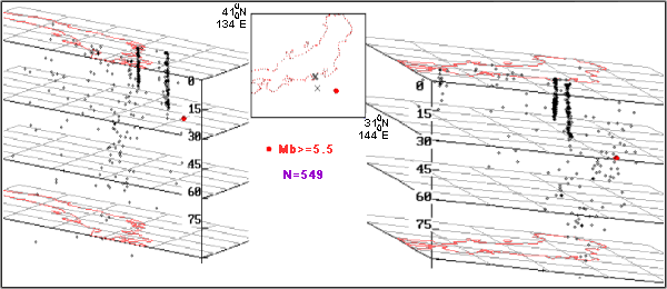
The "nails" length in depth is 20-30 km. The other earthquakes,
occurred in this time period and in this area, form diffusive type of spatial
distribution. The earthquake with magnitude Mb=5.6 happened to the east at
a considerable distance from the "nails".
The multitude of "nails", formed during the year of 1984 on the
area 28oN-38oN and 127oE-137oE, are plotted in two
projections in the next figure.

Situation of the recent active volcanoes is shown by triangles on
the surface. It is seen that the relative position of "nails" and volcanoes
does not allow to tell about direct correlation between them.
This Figure illustrates also the process of gradual forming of seismofocal
zone.
How the "nail" grows
The sequence of appearance of earthquakes in time during of "nail"
forming is shown in depth-time (H,t) diagrams below.
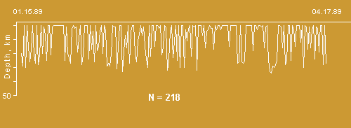
Conditional time on horizontal axis presents moments of rise of
events. It is clearly visible how the process of rise of diffusive
distributed events is changed by spatial localized process of "nail"
formation. Any trend in time-depth dependence during "nail" formation
in the figure is absent.
For determination of the existence of dependence of the current
event depth in "nail" from the depth of precedent the transitional
probability matrix was calculated for four depth intervals. This matrix
hasn't the Markov property. So the "nail" forming takes place in all
depth interval at once, and there is the directional growth of "nail"
neither upwards nor downwards. Strong earthquakes with magnitude more
than 5.0, occurring inside the "nail", do not change the character of
"nail" forming process.
The number of earthquakes N per day during "nail" forming in the
period from 15 January to 22 February of 1989 in the central part of
Hokkaido island is shown
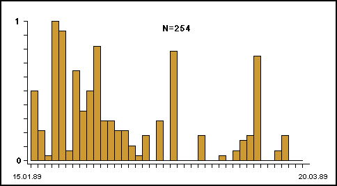
From this figure we notice that exponential decay N(t) does not
exist.
Why the "nail" forms?
Relative to time scale of tectonic processes, which cause
seismicity in a region, the "nail" is shortlived local phenomena.
Time of "nail" forming is considerable longer than time of one
earthquake. Spatial distribution of "nails" has fractal character
( Rys and Valdvogel, 1986 ).
Unfortunately the thirteen years interval (1983-1996) is too short to
determine time and spatial "nails" characters with assurance. But
characters of single "nail", defined in this work, suggest that fluid
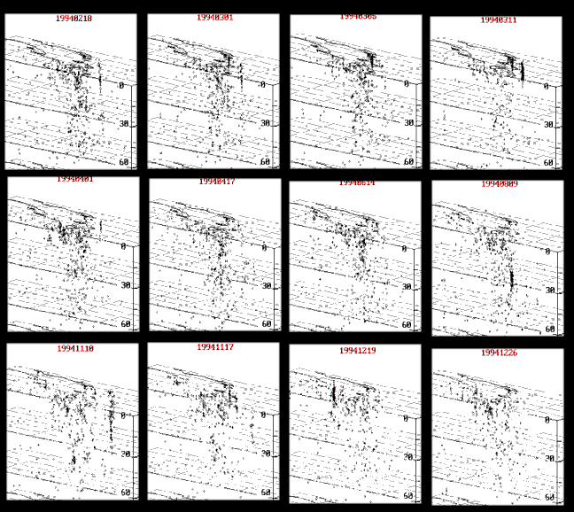
dynamics has important role in "nails" forming process. Figure below
demonstrates as set of the "nails" formed in one region during some
days step by step.
The sequence of stages of nails forming
Intensive processes of serpentinite dehydratation and releasing
of free water during partial melting of wet amphibolite take place in
upper part of subducting oceanic plate
( Ringwood, 1975 ),
( Brimhall and Crerar, 1987 ),
( Fedotov, 1976 ) .
The quantity of water, obtaining in the above-mentioned critical point,
may be sufficient to carry out explosion-like reactions.
Nonlinear processes of fluid dynamics are discussed in many
publications
( Brimhall and Crerar, 1987 ),
( Suetnova, 1995 ),
( Natale and Salusti, 1996 ),
( Aharonov et al., 1995 ),
( Abdrahaimov et al., 1996 ).
Estimates of time and space characters, given in these publications,
agree with our results.
Conclusion
Developed method of investigation of seismofocal zone near Japan
Islands, using JMA catalogue, permitted to find the existence of seismic
"nails" - isometrical, oriented near vertical, compact and very shortlived
buildups of earthquake hypocentres. They located in the depth range
0 - 100 km in the hanging wedge of the crust and mantle beneath Japan arc
and in other regions. The "nail" forms at once along the whole its length
in depth range 15-30 km. It has been suggested that fluid dynamics processes
in lithosphere possible play a role of contributor in "nail" forming.
Acknowledgements
I thank S.A. Fedotov, G.A. Sobolev, S. Uyeda, H.V. Koronovsky,
N.A. Sergeyeva, V.S. Zakharov, L.I. Demina, A.U. Bychkov for helpful
comments and suggestions.
Bibliography
A,
B,
C,
F,
G,
H,
K,
M,
N,
O,
R,
S,
T,
V,
     Abdrahaimov M.Z., Kuznetzov U.I., Zonn M.S.
       Structure of porous space deep earth crust formation.
       P.E.P.I., N 5, 35-45, 1996.

     Aharonov E., Whitehead J.A., Kelemen P.B.
       Channeling instability of upwelling melt in the mantle.
       J.G.R., v. 100, B10, 20433-20450, 1995.

     Brimhall D.H., Crerar D.A.
       Ore fluides: from magmatics to hypergene.
       In: Thermodynamic modelling of geological materials: minerals,
       fluids and melts.
       Mineralogical Society of America, 1987.

     CDIAC's  Numeric Data Package Collection. Version 1.02.
       WDC-A, File NDP 013 .

     Fedotov S.A.
       About upwelling of basic magmas in the Earth crust.
       Izv. AN USSR, Geological series, N 10, 1976, (in Russian).

     Geological structure.
       Uemura T., Mizutani S., Eds.
       John Wiley & Sons Ltd., 1984.

     Global  Hypocentres Data Base CD-ROM.
       Version 3.0, File JMA, 1994.

     Global  Hypocentres Data Base CD-ROM.
       Version 3.0, File PDE, NEIC, USGS, 1994.

     Hasegawa A., Umino N., Rakagi A.
       Doubled-planed seismic zone and upper mantle structure in
       the Northeastern Japan arc.
       Geophys. J. Roy. Astr. Soc., v. 54, N 2, 281-296,1978.

     Hasegawa A., Zhao D., Hori S., Yamamoto A., Horinchi S.
       Deep structure of the northeastern Japan arc and its relationship
       to seismic and volcanic activity.
       Nature, v. 352, N 6337, 683-689, 1991.

     Khain V.E., Lomize M.G.
       Geotectonic with elements of geodynamic.
       MSU, Moscow, 1995, 480 pp., (in Russian).

     Magnetic  lineations of the World Ocean.
       Compiled by Candy S.C., LaBreque J.L., Larson R.L., Pitman III W.C.,
       Golovchenko X., Haxby W.F.
       AAPG, USA, 1989.

     Natale G., Salusti E.
       Transient solution for temperature and pressure waves in
       fluid-saturated porous rocks.
       Geophys.J.Int., v. 124, 649-656, 1996.

     Okada T., Matsuzawa T., Hasegawa A.
       Shear-wave polarisation anisotropy beneath the north-eastern part
       of Honshu, Japan.
       Geophys.J.Int., v. 123, 781-797, 1995.

     Read H.H., Watson J.
       Earth history. Later stages.
       London, 1978.

     Ringwood A.E.
       Composition and petrology of the Earth's mantle.
       McGraw-Hill Book Company, 1975.

     Rys F., Valdvogel A.
       The analysis of fractal dimention of the clouds.
       In: Fractals in physics, Pietronero L. ed.
       North-Holland, 1986.

     Suetnova E.I.
       Metamorphic fluid transport in subduction slab.
       In: 5-th Zonenshain conference on plate tectonic. M., 1995.

     The Seismological  Bulletin of the Japan Meteorological Agency
       for January 1993. Introductory Notes.
       Tokyo, 1994.

     Vadkovsky V.N.
       Seismic "nails": nature and mechanism.
       "Lomonosov readings, 1996", 63-64, MSU, Moscow, 1996, (in Russian).
URL:
http://www.wdcb.ru/sep/traverses/Japan_Geotraverse/paper2.html
2001-2016 © WDC for SEP,
GC RAS
webmaster
|


