|
|
|
|
|
Earthquakes in the seismically active zones of Central Asia, 1911−1957
|
The database includes earthquake catalogues compiled by processing data from a network of
stationary seismic stations in the USSR using a unified methodology with an assessment of the reliability of the results, maps of the
location of earthquake epicenters, information about seismic stations, descriptions and bibliography.
The catalogues converted into electronic form (PDF, Excel and ASCII formats) contain standard values of the parameters of each earthquake:
the moment of occurrence, the source position with an assessment of its determination accuracy,
the intensity and magnitude.
The data presented here are a retrospective addition to the earthquake catalogue
of the Central Asia and Kazakhstan, starting in 1962 and
formed on the basis of data published in the yearbooks «Earthquakes in the USSR»
and «Earthquakes of Northern Eurasia».
Data source: Atlas of earthquakes in the USSR.
The results of observations of the network of seismic stations of the USSR, 1911-1957.
Eds. E.F. Savarensky, C.L. Solovyov, D.A. Kharin. AS USSR Publishing House, Moscow, 1962.
When creating the earthquake catalogue of the seismically active zone of Central Asia (West)
(Kopet-Dag, Turkmenistan), the source material related to the territory of 36−44° N, 52−65° E was used.
Description and bibliography.
Maps.
Information about seismic stations.
The main catalogue of the western seismically active zone of Central Asia includes data on 150 earthquakes of I−V intensity groups
for the period from 1914 to 1957 and 3 events for the period from 1893 to 1895.
The additional catalogue contains
data on 28 events of III−IV intensity groups for the period from 1912 to 1948,
which were not included in the main catalogue due to the unreliability of their definition.
Based on data from expeditionary seismic observations carried out in the western part of Central Asia from 1949 to 1953,
two catalogues have been compiled:
Catalogue of earthquakes in
the Caspian region (southwestern Turkmenistan),
containing data on 180 events in 1951−1952 on the territory with coordinates 38.6−40.5° N, 53.0−56.3° E.
Catalogue of earthquakes in
the Ashgabat region,
containing data on 165 events in 1949 and 1953 on the territory with coordinates 37.6−38.3° N, 57.5−59.0° E.
Catalogues converted into PDF, Excel and ASCII formats.
Format description.
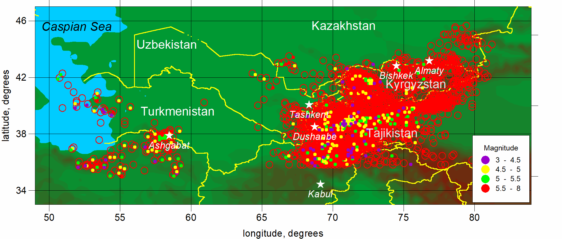
Scheme of the spatial distribution of earthquake epicenters in the Central Asia.
Red hollow circles indicate earthquakes for which the magnitude is not determined
When creating the earthquake catalogue of the seismically active zone of Central Asia (East),
the source material related to the territory 36−46° N, 64−81° E was used.
Description and bibliography.
Maps.
Information about seismic stations.
The main catalogue of the eastern seismically active zone of Central Asia contains data on 706 earthquakes of I−IV intensity groups
for the period from 1911 to 1957 and 11 events for the period from 1885 to 1907.
The second part of
the main catalogue includes data on 8940 earthquakes of I−V intensity groups for the period from 1930 to 1956.
The additional catalogue
contains
data on 117 events of II−IV intensity groups for the period from 1911 to 1948, which were
not included in the main catalogue
due to the unreliability of their identification.
Based on data from expeditionary seismic observations carried out in the eastern part of Central Asia from 1949 to 1953,
two catalogues have been compiled:
Catalogue of earthquakes in
the Garm region (Tajikistan), containing data on 462 events in 1949, 1950 and 1952
on the territory with coordinates 38.3−39.6° N, 69.6−71.4° E.
Catalogue of earthquakes of
the Northern Tien Shan,
containing data on 765 events from 1951 to 1956 on the territory with coordinates 41.8−44.6° N, 74.8−79.7° E.
Catalogues converted into PDF, Excel and ASCII formats.
Format description.
|
|
|
|

 Data distributed under license