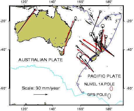

In order to test the most recent plate model, NUVEL-1A, at the Australian-Pacific plate boundary and the possibility of a change in the rate or position of the Euler plate motion pole over time, a regional cooperative GPS survey was conducted on the islands in and around New Zealand (see figure). The plate boundary here is of particular interest because since it is a non-spreading boundary and there are complications in interpreting the earthquake slip vectors, the Australian-Pacific Euler vector is predicted only indirectly from a circuit of data from other plate boundary pairs. This pole is therefore inherently less well constrained than other major poles in NUVEL-1A.
The resulting GPS velocities are compared with NNR-NUVEL1A vectors in the figure. A fit of the GPS velocities gives an Euler vector of -62.9±1.0 N, 180.2±1.0 E with angular velocity of 1.09±0.05 degrees/Myr (see figure, lower right). This GPS-derived pole is comparable in Longitude and rate, but several degrees south of the NNR-NUVEL1A pole. This regional estimate is also 4 degrees west of recent estimates from global space geodetic observations at more distant and widely separated global sites. These results suggest a southward migration of the Australian-Pacific pole of rotation over the past few million years. In order to refine future plate motion estimates of the Pacific plate and to improve global tracking, permanent GPS stations were installed at the Chatham Islands and at Auckland as part of this project.