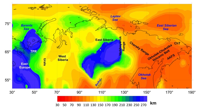
The lithospheric thickness map for northern Eurasia was derived from an integrative
methodology that jointly interprets seismic tomography and gravity data, including gravity
gradients obtained directly from the GOCE mission. As a result, the lithospheric thickness
estimates are considered robust.
Lithospheric thickness across northern Eurasia shows a clear correlation with the age
and tectonic evolution of its major domains.
Ancient cratons, such as the Siberian Craton and the eastern Fennoscandian Shield,
preserve thick lithospheric keels (>200 km) formed through early melt depletion and stabilization.
The apparent southward offset of the Siberian Craton keel relative to earlier reconstructions
suggests later modification, possibly linked to Proterozoic collision or Mesozoic plume activity.
The Timan–Pechora Region (TPR), although younger, is also underlain by thick lithosphere.
This indicates that it is a composite tectonic unit stabilized during Paleozoic orogenesis.
Therefore, lithospheric thickening is not limited to ancient (pre-Cambrian) domains but may also
occur in Phanerozoic collisional systems.
The northeastern Barents Sea represents an intermediate lithospheric fragment
(160–180 km thick) that remains mechanically strong, consistent with a
Proterozoic–Paleozoic subcontinental block incorporated into the Arctic basement mosaic.
The Ural Orogen constitutes a major lithospheric boundary, juxtaposing the thick
East European Craton against the thinner West Siberian Plate. The latter records profound
Mesozoic rifting and plume activity, with potential asthenospheric upwellings contributing
to its present lithospheric structure.
East of the Verkhoyansk Range, the thin (<100 km) tectonically heterogenous
lithosphere area including the Chukotka Terrane, Anadyr–Koryak Fold Belt,
and Kamchatka arc, was shaped by the Phanerozoic subduction process, terrane accretion,
slab rollback, and ongoing arc magmatism.
Overall, the lithospheric architecture of northern Eurasia reflects the interplay
of four major geodynamic processes: (i) craton stabilization in the Archean,
(ii) lithospheric thickening during Paleozoic orogenesis, (iii) attenuation and modification
during Mesozoic plume–rift events, and (iv) active subduction and arc processes along
the Pacific margin. These results underscore the importance of sutures and terrane boundaries
in maintaining strong lateral contrasts in lithospheric thickness and in shaping the
long-term geodynamic framework of Eurasia. The greatest source of uncertainty lies
in the maximum depth of the lithosphere, which is set at 275 km based on thermodynamic
and heat-flow modeling, as well as mantle xenolith thermobarometry.
Although moderate adjustments to this absolute depth are possible, the relative spatial
variations in lithospheric thickness are expected to remain essentially unchanged.
The data set is called Litho_Thickness_km.txt
Data format description.