|
Results of the study of structure of sedimentary basins
in the Eurasia Arctic zone
based on decompensative gravity anomalies
The data was obtained as a result of the study of structure of sedimentary basins in the Eurasia Arctic zone is
analysed by employing the approach based on decompensative gravity anomalies.

Figure 1.Topography and bathymetry of the study area.
Dark grey contours represent positions of sedimentary basins.
The basin captions are in bold.
The dashed line indicates continental
boundaries of the Okhotsk-Chukotka volcanogenic belt (OCVB).
Here and in all subsequent maps the following abbreviations
are used to denote the sedimentary basins:
L-MB – Laptev-Moma basin,
ZB – Zyryanka basin, PrB – Primorsk basin,
TB – Tastakh basin, ChB – Chauna basin,
PeB – Penzhin basin, PB – Pustorets basin,
AB – Anadyr basin.
The sedimentary thickness and density models, differing in their initial conditions,
have been obtained. They demonstrate essentially new details on the structure, shape and
density of the sedimentary basins compared to geological studies
[Koporulin, 1979; Clarke, 1988; Morozov, 2001; Petrov et al, 2016].
First, we computed the isostatic gravity anomalies for the study area, and then we applied
the decompensative correction to the isostatic anomalies. The correction spans within
a range of –50 to +30 mGal and principally changes the isostatic anomaly patterns.
Thus, new details have been obtained, compared to the initial sedimentary model displayed
on Figure 2b and compiled from results by
[Straume et al., 2019; Stolk et al., 2013; Kaban, 2001].
The main discoveries are as follows:
1. Essential changes in the sedimentary thickness and the depocenter location have been
found for the Anadyr basin in its continental part, where the thickness has been reduced
to 1–2 km comparing to previous surveys.
2. New details of the sedimentary thickness variations have been revealed for the central
part of the Penzhin basin, where the thickness appeared to be lower by about two times
comparing to the initial model, and for the Pustorets basin, for which the new location
of the depocenter has been identified.
3. For the offshore part of the Chauna basin (referred as the Ayon basin), the sedimentary
thickness has appeared to be 2-2.5 km in the new model, which is lower than in the initial
model (4 km). The new result agrees with the marine seismic surveys, which confirms robustness of the method.
4. The most significant lateral redistribution of the sedimentary thickness has been
found for Lower Cretaceous coal-bearing strata in the northern part of the Zyryanka basin.
The new model indicates the connection of two coal-bearing zones, revealing the features
of the Lower Cretaceous strata that were not previously mapped due to insufficient geological surveys.
5. New details on the sedimentary thickness variations have been discovered for the Primorsk
basin. The sedimentary thickness in the basin is significantly reduced in the southeast direction.
The overall analysis of two new models confirms the efficiency of the approach based on
the decompensative gravity anomalies. This approach application has made it possible to reveal
several essential changes in the geological structure of the analysed sedimentary basins.
In many cases, the results of our study are the only ones providing the information on the
structure of sedimentary basins in the studied region.
The dataset includes the data grids obtained as a result of the analysis of structure
of sedimentary basins in the Eastern Asia Arctic zone by employing the approach based on
decompensative gravity anomalies. The data are freely accessible.
The study area spans from 135° to 190°E and 65° to 74°N;
the initial area was larger and included the 5600x5400 km in the orthographic projection
with a center point 162.5°E, 72.5°N. This was done for more convenient calculation.
Data and grids in zip archives have the following designations:
- bouguer_gs
- Bouguer gravity anomalies derived from the EIGEN-6c4
gravity field model
[Förste et al., 2014], (mGal), (Figure 2а).
- FAA_gravity
- residual Bouguer anomalies, (mGal).
- total_surface_load
- corrected topography for 2.67 g/cm3, (km).
- isostatic_correction
- map of isostatic correction to the gravitational field, (mGal), (Figure 3а).
- isostatic_anomalies
- map of isostatic gravity anomalies, (mGal), (Figure 3b).
- decompensative_correction
- map of decompensative correction to the gravitational field, (mGal), (Figure 4а).
- decompensative_anomalies
- map of decompensative gravity anomalies, (mGal), (Figure 4b).
- sed_model1
- sedimentary cover thickness model obtained from decompensation gravity anomalies,
(km),
(Figure 5а).
- sed_model2
- sedimentary cover thickness model obtained from decompensation gravity anomalies data
(version 2), (km),
(Figure 5b).
- dens_correction
- density correction map, (g/cm3), (Figure 6а).
- dens_corrected
- the corrected density, averaged vertically, (g/cmг/см3), (Figure 6b).

Figure 2. a - Initial Bouguer gravity data. b - Initial sedimentary thickness model

Figure 3. a - Isostatic correction. b - Isostatic gravity anomalies

Figure 4. a - Decompensative correction. b - Decompensative gravity anomalies

Figureк 5. New sedimentary thickness models. a - Model 1. b - Model 2

Figure 6. a - Sedimentary density correction. b - Sedimentary density model
This work was funded by the Russian Science Foundation (project No. 21-77-30010).
The results are presented in the article:
Roman V. Sidorov, Mikhail K. Kaban, Anatoly A. Soloviev, Alexei G. Petrunin, Alexei D. Gvishiani, Alexei A. Oshchenko, Anton B. Popov, and Roman I. Krasnoperov.
“Sedimentary basins of the eastern Asia Arctic zone: new
details on their structure revealed by decompensative gravity anomalies”.
Solid Earth, 12, 2773–2788, 2021.
https://doi.org/10.5194/se-12-2773-2021
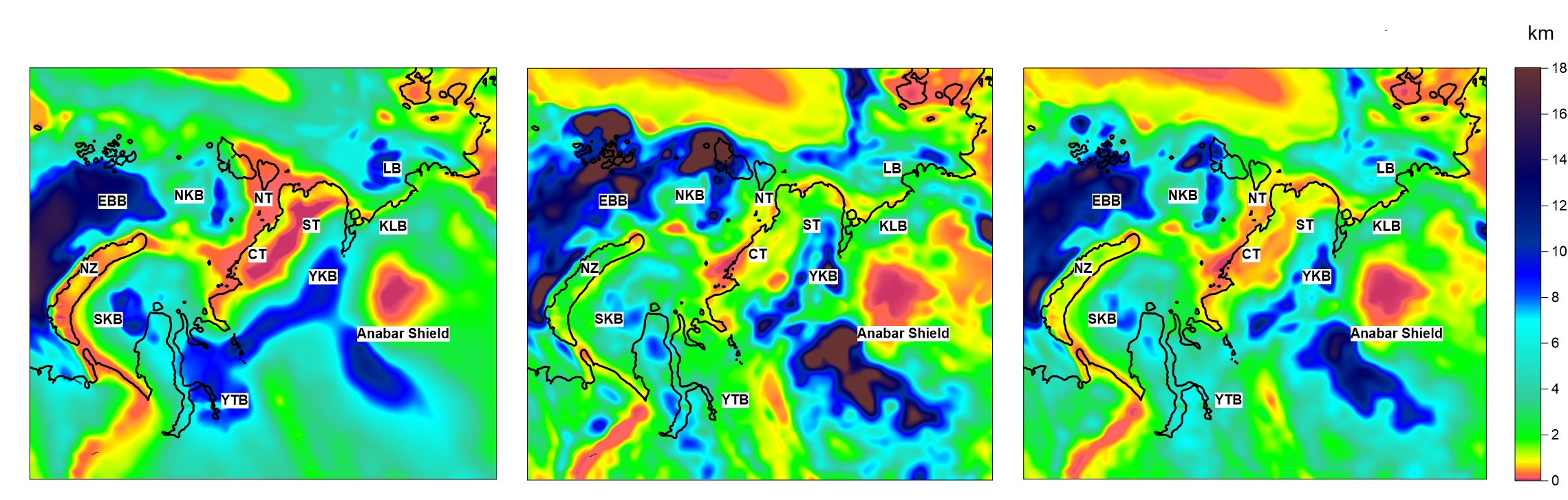
In 2025, the sedimentary cover in another region of Northern Eurasia which included
the northern part of West Siberian plate,
Siberian Craton, northern Ural and the Taimyr orogen, as well as the adjacent continental shelf) was analyzed using the models
based on decompensative gravity anomalies (DGA) calculation (Figure 7).
The models provided a more accurate delineation of regions with complex geological structures,
including denuded mountain-folded zones and areas characterized by thick sedimentary sequences.
This enhanced resolution allows for better identification of depocenters and structural variations
that are not apparent in the initial models.
In shelf regions, the models offer more reliable estimates of sedimentary cover thickness than global datasets such as
GlobSed [Straume et al., 2019].
For example, the models highlight spatial variations in the Laptev Sea Basin, South Kara Basin, and Yamal–Taz Basin,
including clearer delineation of major faults and rift structures.
Also improved detail provided for continental basins.
In particular, the models reveal localized depocenters and subtle variations in sedimentary thickness,
supporting more accurate structural and stratigraphic interpretations.
Due to the small density contrast between deep sedimentary layers and the crystalline basement,
the uncertainties in the models increase with depth, which may lead to overestimation of thickness in deep basins.
Also the intermediate Late Paleozoic–Early Mesozoic units, as well as the contributions from the upper part
of the folded basement complicate the distinction between sedimentary cover and basement, potentially causing
discrepancies with seismic interpretations, where high-velocity layers may be interpreted as basement.
Due to these factors, for deep sedimentary basins the models should be considered primarily qualitative,
providing insight into spatial patterns rather than precise quantitative thicknesses.
Despite these limitations, the DGA-based models provide a valuable tool in regions with sparse borehole and geophysical data,
filling gaps in coverage and enhancing understanding of basin geometry. These refined sedimentary cover models offer a robust
framework for lithospheric and basin modeling, enabling more accurate reconstructions of basin architecture and tectonic evolution
across both continental and shelf regions.

Figure 7. Thickness of sediments in the study area of Nortern Eurasia:
the initial sedimentary cover model (left), and the new sedimentary cover models, 1 (center) and 2 (right)
for the structures of the study area
The results of the study will be published in an article:
Sidorov R.V., Kaban M.K. "Improved Sedimentary Thickness Model for
Central-Northern Eurasia Derived from Decompensative Gravity Anomalies".
RJES, 2025. (In press).
References
Koporulin, V. I. Accumulation conditions and lithogenesis of the Lower Cretaceous
deposits of the Zyryanka basin, Geological Institute of the USSR Academy of Sciences:
Transactions, Vol. 338, Moscow: Nauka. 181 p. (in Russian), 1979.
Clarke J. W. Sedimentary basins of Northeastern USSR, US Department of the Interior,
Geological Survey, URL: https://pubs.usgs.gov/of/1988/0264/report.pdf (accessed on 18.04.2021), 1988.
Morozov, O. L. Geological structure and tectonic evolution of Central Chukotka,
Geological Institute of the Russian Academy of Sciences: Transactions, Vol. 523, Moscow: GEOS, 208 p. (in Russian), 2001.
Petrov, O., Shokalsky, S., Kashubin, S., Sobolev, N., Petrov, E., Sergeev, S.,
Morozov, A., Artemieva, I. M., Ernst, R. E., Smelror, M.: Crustal structure and tectonic model of the Arctic
region, Earth Sci. Rev., 2016. Vol. 154. P. 29-71.
Straume, E. O., Gaina, C., Medvedev, S., Hochmuth, K., Gohl, K., Whittaker, J. M.,
Fattah, R. A., Doornenbal, J. C., Hopper, J. R.: GlobSed: Updated total sediment thickness in the world's oceans,
Geochem. Geophy. Geosy., 20, 1756-1772, https://doi.org/10.1029/2018GC008115, 2019.
Stolk, W., Kaban, M. K., Beekman, F., Tesauro, M., Mooney, W. D., Cloetingh, S.:
High resolution regional crustal models from irregularly distributed data: Application to Asia and adjacent
areas, Tectonophysics, 602, 55–68, https://doi.org/10.1016/j.tecto.2013.01.022, 2013.
Kaban, M. A Gravity Model of the North Eurasia Crust and Upper Mantle: 1.
Mantle and Isostatic Residual Gravity Anomalies, Russian Journal of Earth Sciences, 3,
https://doi.org/10.2205/2001ES000062, 125-144, 2001.
Förste, C., Bruinsma, S. L., Abrikosov, O., Lemoine, J.-M., Marty, J. C.,
Flechtner, F., Balmino, G., Barthelmes, F., Biancale, R.: EIGEN-6C4 The latest combined global gravity
field model including GOCE data up to degree and order 2190 of GFZ Potsdam and GRGS Toulouse, GFZ Data Services:
Potsdam, Germany, https://doi.org/10.5880/icgem.2015.1, 2014.
|
|
|
|


