The concept of ôdepleted mantleö came from isotope geochemistry during the study of the content
of isotopes of uranium, thorium, potassium, rubidium, cesium, etc. and isotopes of light rare earth elements
(lanthanum, cerium, promethium, samarium, etc.) in the upper part of the Earthĺs mantle.
The depleted mantle (geochemically depleted mantle) is that part of the Earth's upper mantle that is depleted
in the above-mentioned and some other elements from the rubidium-strontium and neodymium-samarium isotope systems.
The reason for the depletion of the mantle is the differentiation of the Earth's substance and the Earth's
mantle itself, which occurred during almost the entire geological history of the planet. During the process
of differentiation, lighter elements and compounds moved to the upper layers of the Earth, while heavier
elements and compounds remained in the lower layers. This process also led to the formation of oceanic and continental crust,
which have different densities and thicknesses.
As a result, the mantle beneath the continents is more depleted than beneath the oceans,
where the mantle contains more light elements. Magmatic processes, in particular volcanism,
can also lead to depletion of the mantle. When volcanoes erupt, light elements such as silicon
and oxygen are released from the mantle, which can lead to depletion of the remaining mantle.
According to one hypothesis, it is from the depleted mantle that the basalts of the mid-ocean
ridges are formed by melting.
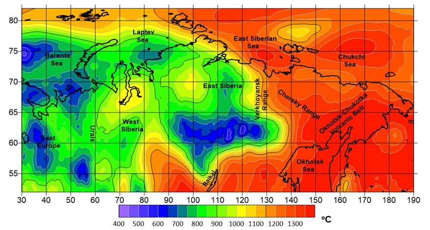
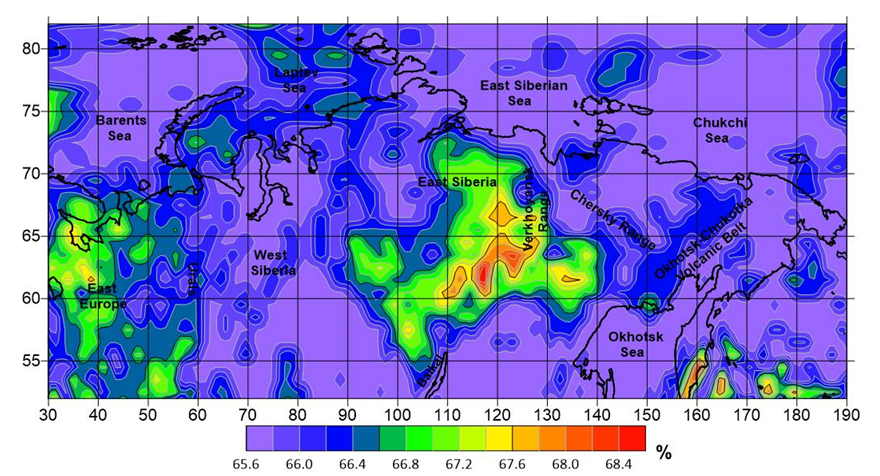
Based on a comprehensive analysis of data on the gravitational field and its vertical derivative,
together with seismic tomography data and mineral physics relationships, the distribution of temperature
(Figure 1) and the rate of depletion of mantle matter in the form of the
percentage of olivine ( Figure 2) was obtained for northern part of the
Russian Federation, including the entire Arctic zone.
Figures display the examples of slices at the depth of 100 km. For modelling the methodology described in
[Kaban et al., 2014; Tesauro et al., 2014] was used.
The horizontal resolution of the thermal model corresponds to the seismic one (0.25°),
and the resolution of the mantle density model is 1°.
All models were obtained for depths of 50, 100, 150, 200, 250 km.
The data files have the following designations:
Description of data format - depletion_format.pdf.

Figure 1. Temperature in the upper mantle at a depth of 100 km

Figure 2. Rate of mantle depletion in the form of percentage of olivine at a depth of 100 km

